
Bulldozers, 30-foot steel, and floodlights are arriving in Big Bend — on a clock Congress did not set.
Story Snapshot
- Homeland Security waived review laws to fast-track wall work across Big Bend counties.
- Customs and Border Protection plans steel bollards, patrol roads, cameras, and lighting.
- Sector apprehensions have dropped sharply, but crossings and patrol needs remain.
- Local lawsuits and conservation groups warn of damage to parks, ranches, and heritage sites.
What Washington Greenlit And Where The Crews Are Headed
Department of Homeland Security issued a formal waiver on February 17, 2026. The agency set aside environmental and cultural protection laws to speed border-barrier construction in the Big Bend Sector.
That action cleared a path for contracting, staging, and on-the-ground work without the usual delays that come with large federal projects in protected landscapes.
Customs and Border Protection then notified landowners across Hudspeth, Jeff Davis, and Presidio counties about survey access and proposed construction corridors.
Trump administration begins construction on Texas’s Big Bend border wallhttps://t.co/0dwLbjanFJ
— The Hill (@thehill) September 19, 2026
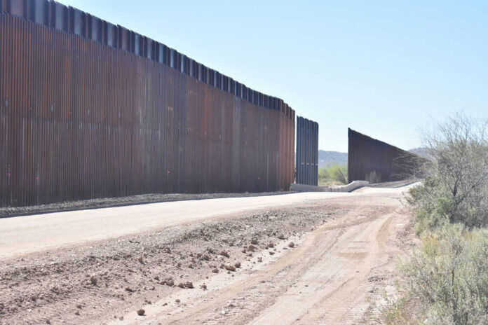
Customs and Border Protection letters and maps lay out specific parts. The plan describes border barrier system construction along roughly 175 miles of the river corridor.
It includes 30-foot steel bollard barriers, motorized and non-motorized gates, drainage features, patrol roads, staging yards, power and fiber optic lines, lighting poles, and surveillance cameras.
The agency also cites water-use needs and utility shelters to power and protect the system, signaling a permanent, staffed footprint rather than a short-term surge.
What The “Smart Wall” Means In Real Life
Agency planning documents show a layered approach. The “Smart Wall” concept combines primary and secondary steel barriers where terrain allows, waterborne barriers in shallow crossings, and technology to tie the system together.
That includes fixed and mobile cameras, sensors, and lighting that support agent response. Later planning maps updated the mix, shifting some steel mileage to technology coverage along about 200 miles, a sign the government is tuning the layout to the ground.
Sensors and lights cut the guesswork at night. In rough canyons or floodplains, cameras and patrols can deliver more value than forcing steel into rock. The public record suggests officials are moving pieces to match that rule of thumb for terrain and access.
The Numbers Critics Quote And The Numbers Washington Watches
Opponents point to a quieter sector. Big Bend’s apprehensions fell to about 3,096 in fiscal year 2025, down roughly 74 percent from 2023. That is a small share of southwest-border activity, and it raises a fair budget question in a tight year: why put heavy hardware where traffic is lighter?
The administration answers with layered enforcement logic. Crossings still occur, and agents still need roads, sight lines, and comms to respond quickly in hours, not days.
That answer is not just theory. Border work here comes bundled with technology and mobility, not just steel. The intent is deterrence plus faster interdiction where the river bends and roads are few. The mix also aims to avoid whack-a-mole.
If sensors catch shifts early, agents can surge to the new gaps. That fits a lesson from past sectors: barriers help most when terrain and response time work with them, not against them.
Courts, Canyon Walls, And The Fight Over Costs And Consequences
Local ranchers, businesses, a nonprofit, and national groups have sued to stop pieces of the project. They argue a wall would slice private lands, dim the region’s famous dark skies, block river access, and damage archaeological sites tied to state landmarks.
Two major conservation groups filed briefs against the build. The coalition also attacks the waiver itself, saying the process steamrolled laws that shield parks and heritage sites from rushed construction.
Customs and Border Protection’s own shifting maps feed doubt. Earlier versions showed longer steel runs; later ones leaned more on cameras and other detection gear.
That change raises questions about which miles truly demand steel and which only need eyes and wheels. If the final build lands closer to a tech-heavy grid with targeted barriers, the project may answer many local concerns while keeping agents effective on the ground.
What To Watch Next: Scope, Tradeoffs, And Time
Congress will pressure agencies to justify mile-by-mile choices. Expect demands for cost-benefit breakdowns that compare steel, tech, and patrols in each canyon and floodplain. Expect more rancher pushback where easements or eminent domain loom.
Also expect operational tests. If the first segments and sensor arrays reduce crossings or speed arrests, the case for selective build-out grows. If not, the scope may swing again toward technology and roads.
One bottom line holds through the noise. Big Bend is rugged and remote. Security there must be layered, light where nature already blocks the way, and firm where the river’s bends invite trouble.
The current plan, on paper, nods to that reality with a hybrid package. The proof will be in the segments they actually build, the tech they light up, and whether agents beat the clock when the alarm trips at 2 a.m.
Sources:
doggett.house.gov, marfapublicradio.org, dallasexpress.com, nobigbendwall.org, yahoo.com, ourpubliclandsandwaters.substack.com, time.com, protectnps.org, ca.news.yahoo.com, theguardian.com, latimes.com